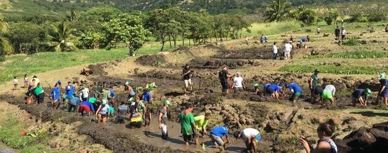
One of the projects that Kaala Farms has been involved with for over 15 years is assisting Waianae High Schools Hawaiian Studies Program as a key partner in their hands-on curriculum in the field, as well as curriculum in the classroom with the idea that students learning in a hands-on approach will perform better in the classroom. I have been overseeing students in the Archaeology Rotation in the field for over a decade, with Aki Sinoto and Moana Lee. My University of Hawaii West Oahu students have also been working in upper Waianae valley, with Kaala Farms being a key partner.
When we started this work in the late 1990s, very little was known of the kinds of historic and cultural sites that were present in the upper valley. Now, 15 years later, with the students finding historic sites and preparing the first detailed maps of these places, we have a much better idea.
The entire landscape from at least half-way through the former Waianae Valley Ranch up into the Forest Reserve is completely covered with historic and cultural sites. This cultural landscape is one of the largest and most important landscapes left on Oahu. It is a place where one can go and touch the house foundation where someone lived 300 years ago, where one can understand how they lived on the land in those times. Vast acres are covered in ruins of fields dryland (or rainfall) fields on the Ranch and irrigated kalo fields from K’maip’ Stream up into the upper valley. Houses of commoners are scattered around on this landscape, and associated with the houses are family shrines and a few identifiable burials.
Agricultural shrines (some small platforms with upright stones) are in the fields. Three large heiau have been found, all on the former ranchlands. These include Punanaula heiau and two previously unknown heiau. Natural features with associated gods and stories (such as Mt. Kaala and Puu Kawiwi) and springs and streams also are part of this cultural landscape. We have far from finished finding all the places in the upper valley, as our program is a slow paced educational program. Many more years of work will find more places, likely with the landscape extending all the way to the base of the steep valley walls. But this educational program is an important one, teaching Hawaiian students science, history, how people lived on the land in the past, and current issues related to cultural and historical sites.
The information from this work also is bringing together as partners the multiple controllers of the land in the upper valley, to attempt to protect this very important cultural landscape and see that it is used in culturally appropriate ways in the future for the benefit of Native Hawaiians on the Waianae coast and in the State in general.
The fire that burnt into the upper valley this summer into and behind the Cultural Learning at Kaala clearly caused damage. But at the same time, it burnt off the thick grass that covered the land. This enabled us to take a closer look at some of the historic and cultural sites that we had been documenting in the past a new and different look. We were able to better see irrigated kalo terraces along the base of Kaua’puu Ridge (on the Lualualei side of the valley). Where we thought no terraces survived, we found the land entirely covered with low stone lines. The fire also helped us identify where water had been diverted out of the streams in the past into fields. All of this information is helping us better plan for protecting the cultural landscape of upper Waianae and planning for future uses that will be culturally acceptable, such as putting some irrigated kalo fields back into production.
Ross Cordy
Professor, Hawaiian-Pacific Studies
University of Hawaii West Oahu